|
Cycle Oregon is a seven-day, non-competitive bicycle tour through the awe-inspiring landscape of various regions of Oregon. The 1998 tour which was Cycle Oregon 11 covered 475 miles of spectacular scenery, with daily rides that ranged from 45 to 80 miles. There were optional routes which offered additional, more difficult, mileage for those intent on a superhuman challenge. I biked the basic tour of 475 miles including numerous stops and several miles of hiking. On the road and at each night's campsite we enjoyed the small town hospitality which was supported by an astounding array of services.
I joined a friend, Mark, and his three brothers. This was my first bike tour of any kind and it was Mark's fourth or fifth Cycle Oregon. I spent the summer riding approximately 700 miles getting ready to join Mark, his brothers and some 2000 other bikers.
The tour (Course Map) begins and ends at Myrtle Creek, Oregon. In between, we had stops at Glendale, Butte Falls, Diamond Lake, Glide, and Elkton. At each stop, we setup camp in an open field.

This is a picture of tent city at Mill Site Park in Myrtle Creek on Saturday afternoon before the first day of Cycle Oregon. My tent is in there somewhere.
Day One - Myrtle Creek to Glendale
The first day on Cycle Oregon was 47 miles from Myrtle Creek to Glendale with an option to climb and descend 3,000 feet over an additional 20 miles. Without the optional climb, the 47 miles was a gradual climb from an elevation of 620 feet to an elevation of 1400 feet. Just north of the first rest stop at Riddle Community Center was Nickel Mountain, the only nickel mine in the U.S. The route followed Cow Creek to lunch and into Glendale. I rode the basic 47 miles and used the first day as a warm-up for the rest of the tour.

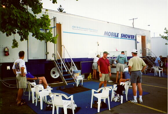
Shower truck; men's on left and women's on right with sink in middle

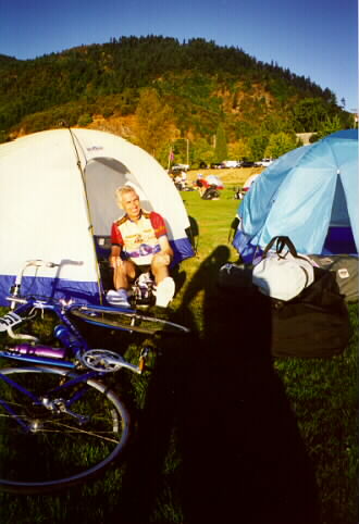
Jerry sitting with new shirt at tent

Bike Corral at Lunch Stop

Jerry at Bad Bridge
at Cow Creek
Day Two - Glendale to Butte Falls
The second day was a distance of 79 miles from Glendale to Butte Falls with several climbs exceeding 1000 feet. It began with a climb past Galesville Reservoir and the headwaters of Cow Creek. A turn on Snow Creek Rd. signaled the start of the real climb, to the summit of Goolaway Gap. A great descent followed the climb with a coast to lunch hosted in the forested seclusion of Elderberry Campground. After lunch, the descent continued into open grasslands with a spectacular view of Mt. McLoughlin. One final climb at the end of the challenging day took us to the small town of Butte Falls. The final elevation of Butte Falls is 2550 feet.

Larsen brothers; Nick, Rich and Mark

Add Ellen and Kathy and you have a chorus line

And I had to get into the act


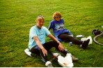
Ellen, Rich, Kathy and Jerry finding the only
shade from the heat that rose into the mid-90s

Mark, Nick and Eric enjoying dinner under
the big tent which was setup each day
Day Three - Butte Falls to Diamond Lake
The third day was a distance of 64 miles from Butte Falls to Diamond Lake primarily from 2500 feet to over 5000 feet. Rolling hills led us through Prospect and on to lunch at Natural Bridge Campground. A walk down to the mighty Rogue river shows us how lava and river co-exist. After lunch, the journey continued to the pristine shores of Diamond Lake between Mt. Bailey and Mt Thielson.

That's Rich in the middle with the
Bell shirt at the Medco Pond rest stop


Rich, Nick, Mark and Jerry having lunch at the National Bridge campground


Rich, Mark and Nick at our
campsite at Diamond Lake
Day Four - Diamond Lake To And Around Crater Lake
Today was a choice to ride your bike or relax on the shores of Diamond Lake. For me, the only choice was to experience the entire Crater Lake by pedaling around (up and down) the rim, have lunch and coast back to camp at Diamond Lake. The other choices were: (1) to ride to the rim and back to camp; and (2) to ride around Crater Lake two times for a century. My choice was for 64 miles. Along the way, information kiosks explained the lore and legend of the lake.
 Rich is coming into the first stop
at the North Junction of Crater Lake.

Mark, Nick and Jerry at the first stop
about ready to head around the lake.


Jerry and Mark showing off
at the rim of Crater Lake
Rich and Mark at the same stop

Nick is resting in his tent at Diamond
Lake reading the Cycle Oregonian.

Our tents at Diamond Lake campground,
my bicycle in background.
Day Five - Diamond Lake to Glide
Today's ride is a glide of 68 miles into Glide, the host community, with a descent of more than 4,000 feet. Along the way are several beautiful waterfalls flowing into the waters of the North Umpqua River. I visited each of the six waterfalls which included some hiking. In Glide, two rivers collide and flow to the Pacific Ocean as the Umpqua River.

Watson Falls - The highest waterfall in Southwest Oregon,
plunging 272 feet over the edge of a basalt lava flow
Day Six - Glide to Elkton
The original day from Glide to Elkton was to be the most challenging day of the tour. The trip was changed because of road repair over a 3500 foot climb to a much less demanding day. The destination of Elkton was a ride of 76 miles over rolling hills and a consistent day of rain. Elkton sits above the Umpqua River and looks down over the site of Fort Umpqua, a Hudson Bay Trading Company.

Eric and Nick ready to hit the pavement


Eric at a popular stop along the way
Day Seven - Elkton to Myrtle Creek
Meandering streams, dense forests, and alpine meadows provide the terrific closing chapter to one of the greatest weeks of cycling in America. Rolling hills led us to lunch at River Forks Park. A few more rolling hills for a total of 79 miles brought us home to Myrtle Creek. A big welcome awaited us at the finish.
Kathy and Ellen resting for lunch
at River Forks Park

There were a lot of riders as indicated
by these signs on the roadside

The view coming into Myrtle Creek

The four brothers and I

All the rider's bags dropped off to be picked up

That's Mark carrying my bag, I was tired!!
|


